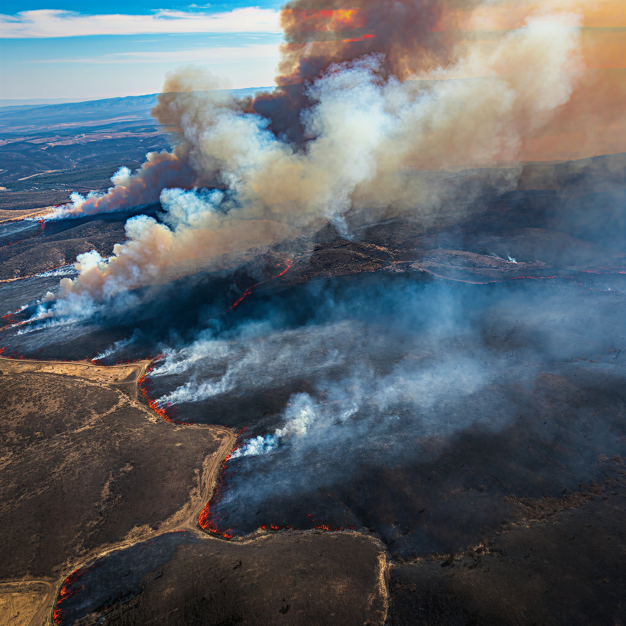
Managing wildfires has always been a daunting challenge for firefighters. With fires spreading rapidly and unpredictable wind patterns complicating efforts, quick and accurate data is essential to make informed decisions. Enter NASA’s advanced airborne sensor, AVIRIS-3 (Airborne Visible Infrared Imaging Spectrometer 3), an innovative tool that is revolutionizing wildfire management by providing real-time data that empowers firefighters on the ground.
This article explores how AVIRIS-3 works, its applications in combating wildfires, and the incredible impact it’s already making.
How AVIRIS-3 Captures Crucial Wildfire Data
NASA’s AVIRIS-3 is an airborne imaging spectrometer that collects infrared data to detect and map wildfires. This data, invisible to the human eye, allows it to sense heat and identify active flames, hotspots, and burned areas in tremendous detail.
Mounted on a King Air B200 aircraft, AVIRIS-3 operates by flying over wildfires at an altitude of about 9,000 feet (3,000 meters). During flights, it scans the land below, using advanced sensors to measure sunlight reflected from the Earth’s surface. By focusing on specific wavelengths, particularly infrared light, it captures detailed information about fire intensity and spread.
One distinguishing feature of AVIRIS-3 is the ability to process data almost instantaneously. Unlike conventional imaging spectrometers that require days or weeks for analysis, AVIRIS-3 processes its findings within minutes, making it invaluable during fast-moving wildfire situations.
Transforming Raw Data into Actionable Insights
Once AVIRIS-3 collects the infrared data, its onboard systems process it to create visual maps of the affected area. These maps are coded with colors to convey heat intensity:
- Yellow indicates the most intense flames.
- Orange and red represent cooler-burning areas.
- Dark red or brown highlights burned regions.
This fire mapping process not only identifies the perimeter of the fire but also pinpoints hotspots that require immediate attention. Additionally, a specialized map, called the “Fire 2400 nm Quicklook,” isolates infrared light at a wavelength of 2,400 nanometers, making it particularly effective for identifying fire perimeters and hotspots.
Real-Time Data Transmission to Firefighters
Speed is of the essence when battling wildfires. AVIRIS-3 seamlessly transmits its processed data via airborne satellite internet. The imagery, once analyzed, is shared directly with firefighters through mobile devices. This enables fire crews to access the latest fire maps during active operations.
Minutes can make the difference between saving homes, forests, or even lives, and AVIRIS-3’s ability to relay this critical information in near real-time represents a revolutionary step forward.
Firefighters in Action: How Data Guides Decisions
With access to AVIRIS-3’s live fire maps, firefighters can make informed decisions about resource allocation and containment strategies. Here’s how they utilize the data:
- Determining Fire Perimeters: Fire crews use the maps to establish and reinforce fire breaks at strategic locations to prevent further spread of flames.
- Identifying Hotspots: The maps help firefighters focus on areas with the highest heat intensity, ensuring resources are directed to where they’re most needed.
- Optimizing Resource Use: Knowing the fire’s exact perimeter helps prioritize personnel and equipment deployment, enabling faster containment.
One compelling example occurred near Castleberry, Alabama. During a wildfire, AVIRIS-3 provided detailed maps within minutes, helping fire crews focus their efforts on the northeastern edge of the blaze. Similarly, during another incident near Mount Vernon, data from AVIRIS-3 enabled firefighters to establish fire breaks that stopped the fire just 100 feet from a cluster of buildings, saving valuable structures from destruction.
The “Fan Favorite”: Fire 2400 nm Quicklook Map
Among the tools AVIRIS-3 provides, the “Fire 2400 nm Quicklook” analysis has become a favorite among firefighters. By providing clear perimeter outlines, this tool allows crews to act swiftly and strategically, maximizing their effectiveness on the ground.
Ethan Barrett, a fire analyst for the Alabama Forestry Commission, noted that these maps give firefighters a crucial “head start.” With accurate perimeter data, crews can position equipment like bulldozers well ahead of approaching flames. This technology puts them “light-years ahead,” according to Barrett, in scenarios where every moment counts.
Case Studies Demonstrating Impact
The Castleberry Fire
On March 19, AVIRIS-3 detected a previously unreported wildfire consuming 120 acres near Castleberry, Alabama. Within minutes, real-time infrared data was transmitted to local firefighters, who used the information to direct bulldozers and firefighting crews effectively. This rapid response prevented widespread devastation in the area.
Perdido Wildfire Management
Two days after the Castleberry incident, a fire near Perdido, Alabama, threatened to spread to nearby buildings. AVIRIS-3 maps revealed that the fire’s primary hotspot was already contained within established perimeters. With this knowledge, resources were redirected to combat other fires in the region, optimizing the allocation of equipment and manpower.
Mount Vernon Fire Response
AVIRIS-3 data helped first responders in Mount Vernon, Alabama, establish fire breaks in critical spots. This effort successfully prevented flames from reaching four buildings, demonstrating the life-saving potential of real-time fire mapping.
FireSense Campaign and Ongoing Developments
AVIRIS-3’s impact goes beyond just single events. It is part of NASA’s 2025 FireSense Airborne Campaign, which tests innovative technologies for wildfire management. The campaign includes prescribed burn experiments and advanced simulations to fine-tune the system’s capabilities and make it more effective.
NASA is also working on extending these capabilities to drones and satellite platforms, ensuring that future wildfire detection and suppression efforts become even more efficient.
The Future of Wildfire Management
NASA’s AVIRIS-3 has shown the incredible potential of real-time data in addressing wildfire challenges. From saving time and resources to preventing property damage and preserving natural habitats, this technology is a game-changer for firefighters and communities alike.
The integration of advanced airborne sensors into wildfire management represents a step toward smarter, data-driven firefighting. While challenges remain, the ability to transform data into actionable insights is an invaluable advantage in the fight against wildfires.
Firefighters, scientists, and policymakers alike can look to AVIRIS-3 as a model for how cutting-edge technology can protect lives and ecosystems. As NASA continues to refine and expand this technology, the future of wildfire management looks brighter than ever.